







(NEW YORK) -- At least one person has died as a result of the flash flooding emergency currently ongoing in Texas, Gov. Greg Abbott confirmed on Thursday.
The death was reported overnight between Kerrville and Comfort, Texas, Abbott said. More than 70 people have been rescued so far, he added.
Rescue operations are underway for people stranded in homes and potentially larger facilities, with 1,300 emergency personnel responding, according to the governor.
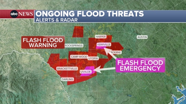
Torrential rain from Wednesday into Thursday prompted flash flood emergency warnings for Texas Hill Country as water levels in creeks and rivers rose rapidly.
As of early Thursday morning, there were two flash flood emergencies ongoing in Texas Hill Country, impacting Kerrville -- the city where the deadly Camp Mystic flooding occurred in July 2025 -- Hunt, Uvalde and Knippa.
Evacuations and water rescues were reported in all four areas, with warnings of life-threatening flash flooding and reports of water entering buildings.
The Guadalupe River at Hunt rose from 9 to 19 feet between 3 a.m. and 4 a.m. CT, cutting off access to some roads and bridges. Just before 6 a.m., the Guadalupe River gauge measured 37 feet at Hunt, and more rise is possible, according to the Kerr County Sheriff's Office.
No camps along the river had sustained any damage as of Thursday afternoon, Abbott said. Warning sirens were activated and functioned properly.
The National Weather Service issued another flash flood emergency later Thursday morning along the Pedernales River, located just north of the Guadalupe River.
A large and deadly wave is moving down the Pedernales River -- with the gauge at Fredericksburg rising to more than 31 feet and counting, according to the NWS.
Engineers assessed the bridge over the Guadalupe River on Highway 87 into Comfort, Texas, due to fears that the force of the water may have made it unstable, Kendall County Judge Shane Stolarcyz told ABC News. The engineers concluded that the bridge is structurally sound for now, ABC News has learned.
There are 63 residents inside the town's evacuation center with their pets, waiting out the storm.
The fast-moving water below the bridge could be seen carrying debris within the current. The water is starting to recede, but authorities anticipate there could be a second wave later Thursday. They do not believe it will be anywhere near the level seen in the morning.
The National Weather Service elevated the flash flood emergency on Thursday to say a "large and deadly flood wave" had begun along the Guadalupe River around Kerrville and was moving through Center Point, which is downstream of Kerrville, and on to Comfort and Waring, Sisterdale, Crown and Bergheim.
The river gauge at Center Point rose 32 feet in four hours and was expected to reach a crest similar to the catastrophic July 4, 2025, river flood.
A rainfall rate of 2 to 4 inches per hour was forecast for the region. Up to 20 inches of rain had fallen in the Uvalde area over the previous 48 hours -- more than six months' worth of rain for this area -- with 8 inches falling in 2 hours.
Abbott said in a press conference on Wednesday that disaster declarations had been made for 59 counties, with the possibility of more being added.
He said that more than 75 people had been rescued so far and that the expected rainfall from this storm could exceed 30 inches, 10 inches more than the level recorded during last year's deadly floods.
"We are dealing with and responding to a flood that is likely going to break records," Abbott said. "There are over 1,300 state personnel from more than 30 agencies that are already activated. More than 800 vehicles, more than 75 boats, and 20 aircraft have been deployed. Our primary focus right now and throughout the remainder of this torrential rain is saving lives."
The NWS issued a flash flood emergency warning for Boerne, located in Texas Hill Country about 55 miles southeast of Camp Mystic, on Wednesday afternoon, urging residents to relocate to higher elevations immediately.
"This is a PARTICULARLY DANGEROUS SITUATION," the NWS warning stated. "SEEK HIGHER GROUND NOW!"
A rain gauge near Boerne measured 3.5 inches of rain within one hour Wednesday morning, according to the NWS. The Cibolo Creek rose 10 feet in just 90 minutes -- between 9:45 and 11:15 a.m. local time, and measured at a record-high level of more than 22 feet.
A flash flood emergency was also issued for D'Hanis, Texas, about 60 miles southwest of Boerne, where between 4 and 10 inches of rain have fallen, according to the NWS. The Seco Creek is rapidly rising, prompting local officials to advise those in flood-prone areas to move to higher ground without delay.
Intense rainfall began in parts of Texas Hill Country on Tuesday, where some areas received between 6 inches and 16 inches of rainfall in 24 hours.
The NWS had previously issued a high risk for flash flooding -- a level 4 out of 4 -- for the same region on Wednesday due to a forecast of an additional 6 to 12 inches of rain.
A "high risk" is a rare occurrence. It's only issued about 4% of days, but accounts for around one-third of all flood-related fatalities and 80% of all flood-related damages, according to the National Weather Service.
Between 4 and 12 inches of rain had fallen by noon Wednesday, and an additional 1 to 2 inches of rain were possible in the area. Flash flood warnings were also issued for Kerrville, Uvalde and just north of San Antonio.
Life-threatening flash flooding occurred at low water crossings, small creeks and streams, urban areas, highways, streets and underpasses, according to the NWS.
In Uvalde County, about 100 miles southwest of Boerne, at least 25 rescues had occurred by 9 a.m. on Wednesday. Additional rescues were underway Wednesday afternoon in North County, where the Leona River gauge reached nearly 20 feet, according to the Uvalde Police Department.
When will the heavy rain, flooding risk end
The flood watch across Texas Hill Country remains in effect through Thursday.
The same area faces a level 4 of 4 risk for flash flooding on Thursday, with the heaviest rain expected between 2 a.m. and 2 p.m. Another round of heavy rain could occur Thursday night.
Isolated additional rain totals of more than a foot are possible through Thursday, forecasts show.
Why Texas Hill Country is prone to flash flooding
Texas Hill Country is often referred to as "Flash Flood Alley," one of the most flood-prone regions in the U.S., because the weather and landscape in the south-central Texas allow for rapid flood events, according to the Texas Water Resources Institute (TWRI).
The "alley," which stretches from Dallas to San Antonio and encompasses the Colorado and Guadalupe River basins, is highly susceptible to dangerous flood events due to its steep terrain, shallow soil and repeated high rainfall events.
Much of the region is situated on a floodplain between tall hills, funneling any rainfall into rivers and creeks, causing them to rapidly rise. In addition, the clay soil does not easily absorb water and triggers high water runoff once wet, the TWRI said.
Major floods have occurred over nearly all sections of the Guadalupe River Basin, according to U.S. Geological river streamflow records dating back to the 1800s.
High rainfall intensities are a common occurrence because the Gulf provides an infinite source of moist air, as does the Pacific, which produces monsoonal moisture as well as cool air masses from the north that converge to produce extreme rainfall events.
Last year, more than 100 people died, including 25 girls at Camp Mystic, as a result of catastrophic flooding along the Guadalupe River during the Fourth of July weekend.
The torrential rain that turned the river into a raging wall of water was fueled by unique atmospheric conditions, meteorologists and climate scientists told ABC News last year.
Heavy rain combined with slow-moving thunderstorms caused the Guadalupe River to rise 26 feet in less than an hour, officials said.
ABC News' Melissa Griffin and Faith Abubey contributed to this report.
Copyright © 2026, ABC Audio. All rights reserved.